Competitively priced BIM Modelling / Guaranteed quality / Fast turnaround
In the realm of architectural, engineering and construction industries, demystifying 3D scanning is an essential step towards leveraging this powerful technology. This post will provide a comprehensive breakdown of the process, from establishing goals to delivering functional applications.
We'll explore pre-planning strategies for successful scanning projects including dealing with security constraints and developing effective mobilisation plans. We'll also examine different data acquisition methods such as terrestrial scanning services and mobile/aerial scanners.
The journey continues through processing/interpretation stages before culminating in practical applications like incorporating scan data into CAD models or using it for animation and virtual reality. As you navigate through our guide on demystifying 3D Scanning: Step-by-Step Breakdown of the Process, you can look forward to gaining insights that could transform your approach to complex projects within your industry.
Before diving into the world of 3D scanning, let's define our project goals. What do we want to achieve with these fancy 3D scanning services?
Are we going for imaginative 3D scanning projects or do we want to incorporate 3D scanning into our long-range scanning applications indoors? The possibilities are endless.
But wait, there's more.
Do we need portable 3D scanners or are we going for the big guns with lab-based systems? It all depends on what we want and like.
Let's discuss the specifics of our requirements. If we want to create detailed digital models, we need to understand shape data quickly. On the other hand, if we're into reverse engineering, raw scan data is the name of the game.
Remember, folks: clear goals and the right tools are the secret sauce to successful 3D scanning projects.
Now that we've got our goals and functional requirements sorted, let's see how partnering up with service providers can make capturing data a breeze. No more headaches, just smooth sailing.
Choosing the right partner is crucial when it comes to employing 3D scanning services for your creative projects. Currently, there is little standardization or regulation in the procurement of 3D scanning services. Therefore, it is important for clients to educate themselves and their organizations about the potential benefits of this emerging technology before starting the procurement process. This evaluation should be done within the context of the AEC industry (Architecture, Engineering, Construction) and take into account the client's willingness to take risks with technological innovation and their previous experience with similar endeavors. When it comes to asset management applications that involve multiple facilities or large asset networks, a cautious approach to partnering with service providers can minimize business risks associated with technological decisions and increase chances of success for clients. In most cases, there are two types of contracts involved in procuring 3D scanning services: 1) Direct contracting between an asset manager/owner and a 3D scanning service provider. 2) Contracting between an asset manager/owner and a general contractor/design consultant who then subcontracts with a 3D scanning service provider. The first type is more common for larger programs that require mobile/aerial scanning or multiple terrestrial mobilizations. The second type is typically seen in new construction projects or rehabilitation/renovation applications. Both contractual vehicles have their own challenges but may require clients to engage a third-party consultant who can assist in developing tender invitations and evaluating service provider expertise. These consultants can also help assess the level of effort needed for post-processing work to develop specified deliverables, which often impacts timeframes and costs but tends to be underestimated by clients.
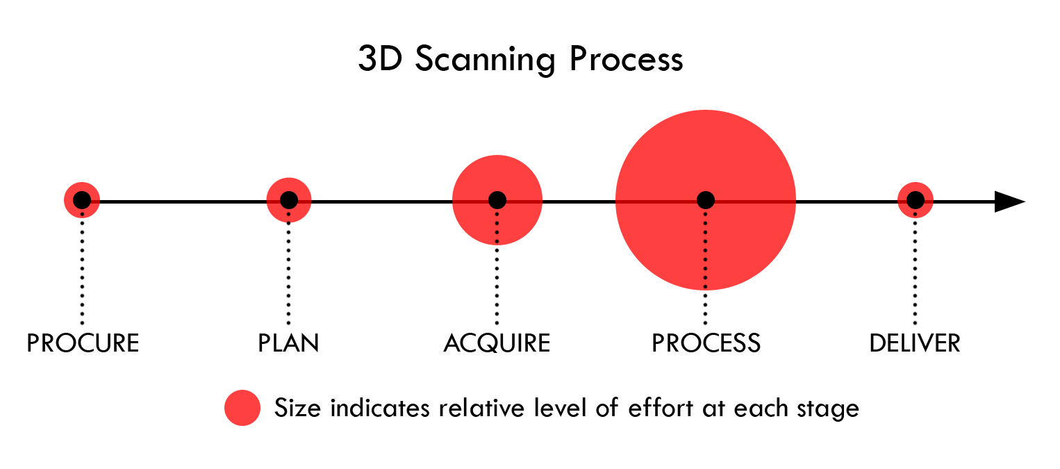
The magic of 3D scanning begins with meticulous pre-planning. You gotta have a plan, man.
Setting clear measurement objectives is the key to a successful project. Don't just wing it.
During this stage, it is important to establish a clear and concise scope for the scanning effort. This includes creating a detailed list of the measurements that need to be taken, specifying the desired resolution and level of detail for each measurement. It is also necessary to determine the required accuracy for each measurement, which may vary. Additionally, the required file format for deliverables should be specified in this stage. While it is crucial to define the scope in the contract, it is beneficial for the service provider to offer advice on different measurement goals that can help achieve functional performance requirements more efficiently and cost-effectively.
No two projects are alike, especially when you employ 3D scanning services. It's like a puzzle, but with lasers.
Sometimes, security issues or access constraints may pose challenges. Gotta tackle 'em head-on.
Ensuring unimpeded access for service providers is crucial to avoid incurring additional costs due to delays in mobilization or accessing target areas. For government buildings and other sensitive security zones, it is important to arrange escorts or obtain additional security clearance before acquiring the field so that service providers are not delayed. The client may be held responsible if these issues cause a delay in the work, so clients should be aware of the challenges that service providers may encounter on-site. It is also necessary to clearly establish any security concerns regarding the acquired data before processing begins, allowing service providers to organize secure storage and transfer of sensitive information. Any safety issues related to scanning personnel should also be addressed at this stage.
A well-thought-out mobilization strategy is crucial. It's like a game plan, but for scanning.
The expertise of the 3D scanning service provider is crucial for developing a mobilization strategy. 3D scanners rely on optical technology, which means that data sets can sometimes have "shadows" or areas where the target object is not fully visible, resulting in incomplete scans. Additionally, the accuracy of the data decreases as distance increases due to laser beam divergence, making it challenging to achieve the desired level of resolution for certain objects. These factors will determine how many scan locations are needed for terrestrial applications or what routes should be taken for aerial and mobile applications. To navigate these considerations effectively, clients may consider consulting with an experienced third-party advisor who can help them discuss and plan their mobilization strategy with the service provider since most clients lack relevant experience in this field.
Control networks are crucial in increasing confidence levels for subsequent data queries, quality assessments, and inferred measurements from a dataset. They play an integral role in the planning process. Control networks can take various forms, such as temporary objects (referred to as "targets") placed within the scanning area, permanent or semi-permanent fixtures like thermoplastics or fixed controls used for periodic scanning, or artifacts with known dimensions like spheres or geometric primitives. These control networks also aid in aligning the data to larger scale mapping networks, known as georeferencing. Scanning software identifies objects within the scene and utilizes this information to align scan data with known controls that have been measured using other equipment like a total station. Some clients may want to establish accuracy requirements for the control network.
We're now at the exciting stage of capturing physical data.
The method? It could be terrestrial, mobile/aerial, or even lab-based systems. Each has its unique applications and advantages in various industries.
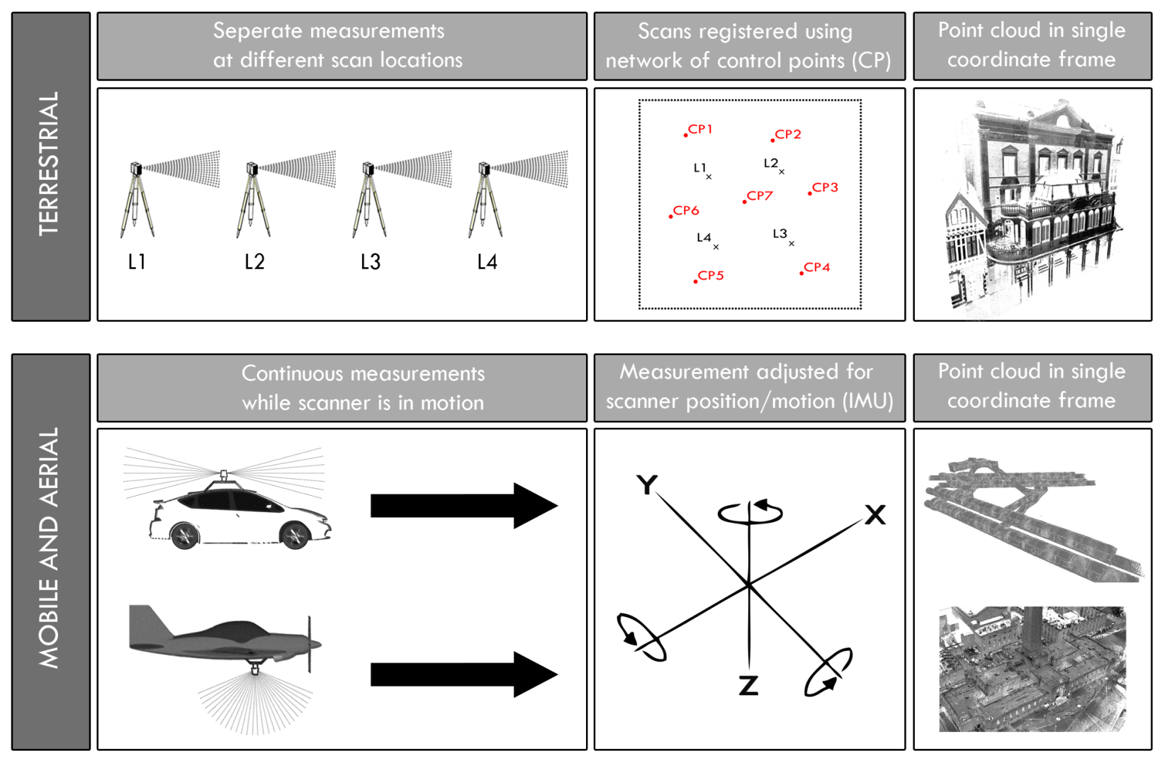
The method of data acquisition differs significantly between terrestrial laser scanners (TLS) and mobile/aerial scanning systems. Typically, tripod-mounted terrestrial scanners are more commonly used for smaller projects involving one or a few facilities, where the focus is on capturing facility features like architectural details, utilities, equipment, or structures. On the other hand, mobile and aerial applications are more suitable for larger networks of assets or creating lower-resolution representations of existing conditions for urban planning or asset management purposes. Additionally, when using fixed-wing aircraft or helicopters for aerial applications, careful planning of the aircraft's path is necessary for large-scale mapping initiatives known as "swath mapping". Due to these distinct capabilities of each system, it is crucial for clients to have a general understanding of the measurement principles associated with each method in order to determine which approach best aligns with their functional performance requirements.
Moving on to mobile/aerial scanners: what's their story?
These portable scanners bring flexibility that stationary scanners simply can't match.
Whether it's surveying vast construction sites or mapping intricate building interiors, incorporating 3D scanning can make capturing data a breeze.
For mobile and aerial applications, a scanner (typically a rotating mirror system with very high data capture rates) is mounted on the vehicle to capture existing conditions as it moves. An Inertial Measurement Unit (IMU) equipped with a GNSS antenna (e.g., GPS) records the geospatial position of the scanner. The processing unit then adjusts the sensed distance measurements based on the motion of the scanner and provides a series of adjusted measurements in a single coordinate frame. This is different from how terrestrial scanners work, where the scanner is manually moved to various positions and each scan is registered in a single coordinate frame using known points in a control network.
Lastly comes measurement validation processes.
Ensuring accurate results means not just relying on raw scan data but interpreting resulting XYZ measurement points correctly.
The goal here? Create detailed digital models and fully textured 3D images that can be used for reverse engineering or other imaginative 3D scanning projects.
So you've employ 3d scanning services and captured your raw scan data using portable 3d scanners or body scanning systems. Now it's time to decode this treasure trove of information.
Don't worry, we'll help you navigate this data-filled journey.
Your scanner has just given you a boatload of XYZ measurement points. It's like having a detailed map in 3D space, showing where every scanned point is hanging out.
It's like playing connect the dots, but in three dimensions.
To make sense of these measurements and turn them into something useful, we need CAD models. CAD, short for Computer-Aided Design software, helps us visualize shape data quickly.
And guess what? CAD modeling isn't limited to flat surfaces. We can even tackle mind-blowing, complex shapes with ease.
Now that we have our digital model ready, let's incorporate 3d scanning into some imaginative 3d scanning projects.
The final phase of 3D scanning: time to get practical.
You've obtained your processed information, so let's find out what can be done with it.
This step involves integrating scan data into CAD models.
Not just for design, we can even reverse engineer with it.
Going beyond the basics, we can use scan data in animation and virtual reality.
Virtual reality (VR) brings real-world objects seamlessly into digital spaces.
With high-resolution point clouds, we can create detailed digital copies of buildings and even entire cities.
And guess what? Portable scanners and body scanning systems make capturing data a breeze, even for industrial applications.
No more manual input needed; machines do it all with precision.
Welcome to the future of 3D imaging with fully automated scanning solutions.
A 3D scanner operates through a series of steps. Initially, it emits a laser or light source onto the object being scanned. The light reflects off the object and returns to the sensor of the scanner, which records precise measurements of distance based on the time taken for the light to return. These measurements are then utilized to generate a point cloud, which is essentially a large collection of data points representing the surface of the object. This raw data is processed using software that converts these points into a digital 3D model. The final stage involves refining and cleaning up this model, eliminating any noise or errors from the scanning process before exporting it into a desired format for further applications such as BIM modeling or construction drawings.
3D scanning is a precise and non-intrusive technology that captures spatial data from objects or environments. It works by projecting a laser onto the subject and analyzing the reflected light to create detailed digital representations. These scans can be processed into various formats like point clouds, meshes, or CAD models for further analysis and use in different fields such as construction, manufacturing, archaeology, and the film industry. In Building Information Modeling (BIM), 3D scanning plays a crucial role by providing accurate data on existing conditions for retrofitting projects or clash detection during design stages. This greatly improves project efficiency and accuracy while reducing rework costs.
There are three main methods commonly used for 3D surface scanning: Laser Scanning, Structured Light Scanning, and Photogrammetry. Laser Scanning employs a laser beam to measure the distance between the scanner and the object's surface, generating a point cloud of data. Structured Light Scanning entails projecting a series of linear patterns onto an object. By analyzing how these lines deform over surfaces, software can calculate depth and detail information. Photogrammetry involves capturing multiple high-resolution photographs from different angles. These images are then processed by software that stitches them together into a detailed 3D model.
Demystifying 3D Scanning: Step-by-Step Breakdown of the Process is your go-to guide for understanding and implementing 3D scanning like a pro. No more confusion, just clear steps to follow.
First, set your goals and partner with the experts at 3D Scanner for top-notch service. They've got the portable scanners you need for all your imaginative 3D scanning projects.
Next, it's time to get scanning! Whether you're employing long-range scanning indoors or going for the classic terrestrial scanning services, capture that raw scan data like a boss.
Once you've got your scan data, it's time to process and interpret. Turn those XYZ measurement points into detailed digital models and create fully textured 3D images that will blow your mind.
Now, let's put that scan data to work. Use it to create CAD models for reverse engineering or bring it to life in animation and virtual reality applications. The possibilities are endless!
With this breakdown, you'll be a 3D scanning pro in no time. So go ahead, start making those digital copies and capturing data like a boss!
Our office in the UK
Our Services